Bathymetric LiDAR Drone Mapping Services
Bathymetric LiDAR mapping services include airborne Drone LiDAR bathymetry and aerial terrestrial LiDAR. Our new 2-in-1 LiDAR system measures and maps underwater features and ocean floor terrain at a centimeter-level depth resolution.
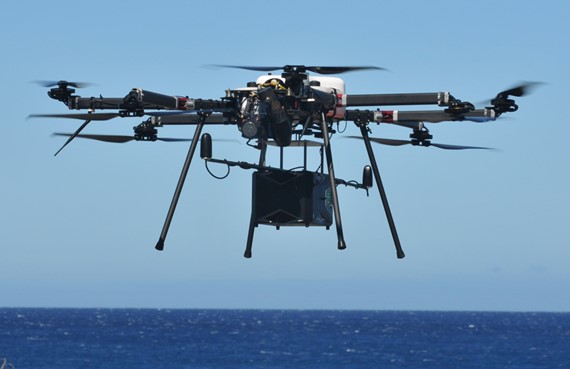
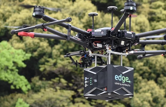
We mount our 2-in-1 LiDAR System on a gas-powered drone to do both Airborne Bathymetric LiDAR and Aerial Terrestrial LiDAR mapping. LiDAR Hawaii makes it possible to measure and map underwater features at a centimeter-level depth resolution for the first time ever.
LiDAR Bathymetry Services
Bathymetric LiDAR Drone Mapping Services
Bathymetric LiDAR Drone Topographic Mapping
Bathymetric LiDAR 3D Digital Elevation Models (DEMs)
Bathymetric LiDAR Mapping Services
Bathymetric LiDAR mapping services are based on the technology and application of airborne laser altimetry or Light Detection And Ranging aka LiDAR. Aerial terrestrial LiDAR is used for mapping terrestrial topography. This type of LiDAR has undergone a rapid evolution over the last few decades. These LiDAR systems have transitioned from being research tools to operational systems which are commercially available in the private sector from LiDAR Hawaii.
The use of airborne lasers to measure bathymetry, however, has not experienced the same development. Bathymetric LiDARs, which employ a blue-green wavelength of laser light to penetrate water, currently remain a very specialized and unique technology with only a handful of SHOALS systems currently in existence. These extremely large and very expensive SHOALS systems must be mounted on a large aircraft in order to collet bathymetric LiDAR data. This makes using SHOALS systems cost-prohibitive for most projects.
Our new 2-in-1 bathymetric LiDAR plus aerial terrestrial LiDAR system ushers in a new generation in LiDAR technology mapping services. The small size of our new dual LiDAR system allows us to use a gas-powered drone for LiDAR mapping. This eliminates the high cost of an aircraft for bathymetric LiDAR mapping. Thanks to the water penetrating capabilities of our advanced LiDAR system, LiDAR Hawaii is now able to perform underwater feature mapping and terrain mapping in shallow ocean, clear lakes, and clear or shallow rivers.
Advantages of our new 2-in-1 LiDAR System:
- Civil Engineering Projects along the coastline or shoreline in combination with aerial terrestrial LiDAR.
- Environmental Studies like mapping and tracking coral reef health and declining coral reef populations.
- Mapping shoreline or coastal erosion or damage caused by natural disasters like flash flooding or tidal waves in conjunction with aerial terrestrial LiDAR.
- Topographical mapping of the seafloor, lake bottoms, and riverbeds and 3D digital terrain models of underwater features.
- Scientific research like geological studies and marine biology research.
What is Airborne LiDAR Bathymetry?
Bathymetry is the study of the physical features of the sea floor. This is often done with bathymetric LiDAR mapping services. Bathymetric LiDAR is the technology and application of airborne laser altimetry or Light Detection And Ranging,
LiDAR, for mapping underwater features and seafloor topography. Bathymetric LiDAR data is used to create topographical elevation maps and digital 3D models aka digital elevation models (DEMs) of the seafloor. Airborne LiDAR Bathymetry mapping is now being done using a gas-powered drone. This replaces traditional SHOALS. Our new 2-in-1 LiDAR system now makes airborne LiDAR bathymetry combined with aerial terrestrial LiDAR a practical and affordable solution for civil engineering projects, land surveying projects, and shoreline or coastal resort, golf course and land developments.
SHOALS Bathymetric LiDAR
SHOALS aka Scanning Hydrographic Operational Airborne Lidar Survey systems were developed as a tool for monitoring nearshore bathymetric environments by the U.S. Army Corps of Engineers. SHOALS systems are used in tidal inlets for collecting data on channel shoaling, changes in shape of ebb and flood tidal shoals and the patterns of sand movement. SHOALS is also used for coastal structure evaluation, protecting shorelines and coastlines, natural disaster emergency response, navigation, and nautical charting.
SHOALS systems are very large and very costly. SHOALS systems must be mounted on a full-size aircraft in order to do bathymetric LiDAR data collection. This cost of the system in addition to the cost of the aircraft makes using a SHOALS systems cost-prohibitive on most commercial projects.